Tanzania West Kilimanjaro - Lake Natron - Lake Manyara - Lake Burunge Safari Ride
9 nights/10 days
Tanzania West Kilimanjaro
NeuFox Travel Pty Ltd
Let’s turn our travel dreams into reality!
Tanzania West Kilimanjaro – Lake Natron – Lake Manyara – Lake Burunge Safari Ride – 9 nights/10 days
Trip starts: 09.00 hrs.
Trip ends: 18.00 hrs.
Duration: 9 nights, 10 days, 8 days riding.
Highlights of the trip
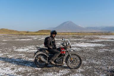
- Ride around iconic Mount Kilimanjaro.
- Encounter African wildlife in the saddle of an iconic Royal Enfield motorcycle.
- Lake Natron’s desert landscapes teeming with African wildlife and Lesser Flamingos.
- Active volcano of Ol Doinyo Lengai.
- Spectacular roads and views along the Great Rift Valley Escarpment.
- Friendly peoples along the way.
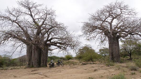
- Hadzabe and Datoga Tribes at Lake Eyasi.
- Magical Wildlife safari in iconic Ngorongoro Crater.
TRIP ITINERARY
Day 1 – Arrive in Arusha
Pick up at Kilimanjaro International Airport and transfer to your hotel for the night located on the outskirts of the city of Arusha town. Check in and settle into your accommodation followed by a meet by your host. Overnight in Arusha at Forest Hill Hotel.
Total Distance to Cover:
Tar road – 0 km; gravel road – 0 km.
Total – 0 km.
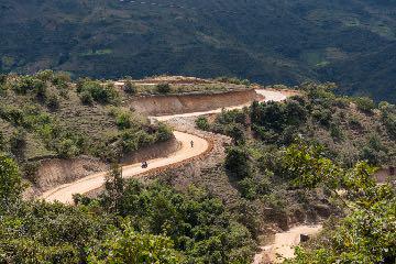
Day 2 – Arusha to West Kilimanjaro
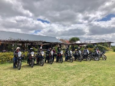
Transfer to our Royal Enfield Center to meet your motorcycle for the trip and have a comprehensive trip briefing. Start the trip by 11.00 hrs and head northward for 30 or so km on a good tar road to then head eastward on a gravel road so as to ride around the northern side of Mount Meru, a beautiful freestanding extinct volcano. Enjoy scenic vistas and scenery. You will ride through bush, open landscapes and forest areas. Your destination for the day is on the foothills of iconic Mount Kilimanjaro. There will be the opportunity for some wildlife viewing during the ride and plenty of opportunity to meet locals. Arrive at your destination by late afternoon to complete your first warm up day of the trip. Check into your accommodation for the night and fire, dinner and overnight at Simba Farm Lodge.
Total Distance to Cover:
Tar road – 90 km; gravel road – 45 km.
Total – 135 km.
Day 2 – Arusha to West Kilimanjaro
Transfer to our Royal Enfield Center to meet your motorcycle for the trip and have a comprehensive trip briefing. Start the trip by 11.00 hrs and head northward for 30 or so km on a good tar road to then head eastward on a gravel road so as to ride around the northern side of Mount Meru, a beautiful freestanding extinct volcano. Enjoy scenic vistas and scenery. You will ride through bush, open landscapes and forest areas. Your destination for the day is on the foothills of iconic Mount Kilimanjaro. There will be the opportunity for some wildlife viewing during the ride and plenty of opportunity to meet locals. Arrive at your destination by late afternoon to complete your first warm up day of the trip. Check into your accommodation for the night and fire, dinner and overnight at Simba Farm Lodge.
Total Distance to Cover:
Tar road – 90 km; gravel road – 45 km.
Total – 135 km.
Day 3 – West Kilimanjaro to Lake Natron
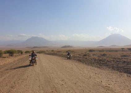
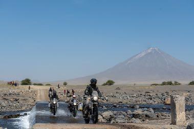
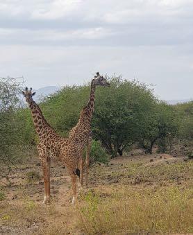
West Kilimanjaro to Lake Natron: Enjoy a hearty early breakfast and prepare your motorcycle for the day’s ride. Today is one of the longest ride days of the trip. Ride out from your lodge by 09.00 and head west away from Mount Kilimanjaro and into the open plains. You will then ride northward and this first section will provide you with some excellent wild game viewing from your motorcycle. Ride all day on gravel roads through African bushlands, grasslands and eventually desert landscapes as you approach the Lake Natron area. Stop for a packaged lunch along the way and continue on with the impressive active volcano of Ol Doinyo Lengai in front of you and the dormant volcano of Gelai to your right. Once well into the gravel road there is a good chance of encountering wildlife, from Giraffe and Elephant to Antelope, Gazelle, Wildebeest, Zebra and the elusive and highly endangered Cheetah. Arrive at Lake Natron by late afternoon and check in to your comfortable accommodation consisting of large safari style tents, close by the lake. Enjoy the spectacular views of the lake, Ol Doinyo Lengai while enjoying a sundowner. Fire, dinner and overnight at Africa Safari Lake Natron.
Total Distance to Cover:
Tar road – 30 km; gravel road – 200 km.
Total – 230 km.

Day 3 – West Kilimanjaro to Lake Natron
West Kilimanjaro to Lake Natron: Enjoy a hearty early breakfast and prepare your motorcycle for the day’s ride. Today is one of the longest ride days of the trip. Ride out from your lodge by 09.00 and head west away from Mount Kilimanjaro and into the open plains. You will then ride northward and this first section will provide you with some excellent wild game viewing from your motorcycle. Ride all day on gravel roads through African bushlands, grasslands and eventually desert landscapes as you approach the Lake Natron area. Stop for a packaged lunch along the way and continue on with the impressive active volcano of Ol Doinyo Lengai in front of you and the dormant volcano of Gelai to your right. Once well into the gravel road there is a good chance of encountering wildlife, from Giraffe and Elephant to Antelope, Gazelle, Wildebeest, Zebra and the elusive and highly endangered Cheetah. Arrive at Lake Natron by late afternoon and check in to your comfortable accommodation consisting of large safari style tents, close by the lake. Enjoy the spectacular views of the lake, Ol Doinyo Lengai while enjoying a sundowner. Fire, dinner and overnight at Africa Safari Lake Natron.
Total Distance to Cover:
Tar road – 30 km; gravel road – 200 km.
Total – 230 km.

Day 4 – Lake Natron
Today is a day to ride the spectacular surrounds of Lake Natron. Do a wildlife viewing game drive on your motorcycle. Hike through a river gorge and cool off in the chilly waters of a spectacular waterfall. Explore the lake shores on your motorcycle and get up close and personal with Lesser Flamingos. Visit a Maasai village and learn about their culture and way of life. Or rather just stay in camp and enjoy a relaxing day by the pool. Overnight at Africa Safari Lake Natron.
Total Distance to Cover:
Tar road – 0 km; gravel road – 50 km.
Total – 50 km.
Day 5 – Lake Natron to Karatu
Ride out from your tented camp at Lake Natron by 09.00 and head south along the Great Rift Valley escarpment. During the ride you will ride among wildlife and pass the foothills of Ol Doinyo Lengai. This is a gravel road with spectacular desert like scenery along the way. You will ride past Maasai tribal villages and have a chance to meet the locals. Visit a large crater along the way. Stop for a packed lunch along the way and ride up the escarpment to a higher altitude as you get closer to destination. Overnight at Hhando Coffee Lodge at the foot of Ngorongoro Crater.
Total Distance to Cover:
Tar road – 5 km; gravel road – 115 km.
Total – 120 km.

Day 6 – Lake Manyara to Ngoro Ngoro Crater
Today you have the option to embark on a spectacular 4 x 4 African Wildlife viewing drive into one of the world’s natural wonders; the Ngoro Ngoro Crater. Ride out from your resort by 06.30 hrs and head west up the Rift Valley escarpment towards the iconic Ngorongoro Crater. The ride up the escarpment offers some great riding up switch-back mountain roads with great views of Lake Manyara and the plains down below. Leave your motorcycle at the park gate and get into a purpose built 4 x 4 game viewing Land Cruiser. Enjoy a drive into the Ngoro Ngoro once active caldera and now one of the world’s premiere wildlife viewing areas, a real life ‘Garden of Eden’. Expect to see get up close for great photo opportunities at Rhino, Elephant, Lion, Cheetah, Leopard, Gnu, Buffalo, and a myriad of Gazelles and Antelope. Exit the park by 17.00 hrs to get back in the saddle of your motorcycle and ride back to your lodge at Lake Manyara for the night. Overnight at Hhando Coffee Lodge.
Total Distance to Cover:
Tar road – 120 km; gravel road – 0 km.
Total – 120 km.
Day 7 – Lake Manyara to Lake Eyasi:
Lake Manyara to Lake Eyasi: Depart Lake Manyara by 09.00 hrs and ride towards beautiful Lake Eyasi. Ride once again up the beautiful Rift Valley Escarpment towards Ngoro Ngoro Crater and veer off into a gravel road that will take you through scenic forests and vistas towards Lake Eyasi. Arrive at Lake Eyasi in time for lunch and settle into your lodge for the night. Afternoon optional visit to the Hadzabe tribe or ride along the lake shore (approximately 60 km). Return to your lodge by sunset and overnight at Kisima Ngeda Tented Camp.
Total Distance to Cover:
Tar road – 40 km
Gravel road: 40 km.
Total – 80 km.
Day 8 – Lake Eyasi to Lake Burunge:
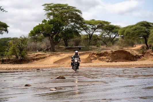
Lake Eyasi to Lake Burunge: This will be a full day off-road riding down trails and rugged roads leading from Lake Eyasi and circumnavigating Lake Manyara. Depart from your lodge after a hearty breakfast and ride eastward from Lake Eyasi to the escarpment above Lake Manyara. These are challenging tracks and rugged roads rarely driven by cars. Enjoy some challenging riding with dry or wet river crossings, encounters with magnificent vegetation and peoples, and breathtaking views of Lake Manyara and the plains below. Stop for lunch at a local restaurant and then proceed to ride down the escarpment and join the trunk road network on the south side of Lake Manyara so as to ride to Lake Burunge on the outskirts of Tarangire National Park. You are once again in wildlife areas and encounters with wildlife while riding your motorcycle are likely. Dinner, fire and overnight at Lake Burunge Tented Lodge.
Total Distance to Cover:
Tar road – 60 km
gravel road: 140 km.
Total – 200 km.
Day 8 – Lake Eyasi to Lake Burunge:
Lake Eyasi to Lake Burunge: This will be a full day off-road riding down trails and rugged roads leading from Lake Eyasi and circumnavigating Lake Manyara. Depart from your lodge after a hearty breakfast and ride eastward from Lake Eyasi to the escarpment above Lake Manyara. These are challenging tracks and rugged roads rarely driven by cars. Enjoy some challenging riding with dry or wet river crossings, encounters with magnificent vegetation and peoples, and breathtaking views of Lake Manyara and the plains below. Stop for lunch at a local restaurant and then proceed to ride down the escarpment and join the trunk road network on the south side of Lake Manyara so as to ride to Lake Burunge on the outskirts of Tarangire National Park. You are once again in wildlife areas and encounters with wildlife while riding your motorcycle are likely. Dinner, fire and overnight at Lake Burunge Tented Lodge.
Total Distance to Cover:
Tar road – 60 km
gravel road: 140 km.
Total – 200 km.
Day 9 – Lake Burunge to Arusha:
Lake Burunge to Arusha: Today is the final riding day of the trip. Leisurely wake up and breakfast by 09.00. Then set off on your motorcycle for a short but scenic ride back to Arusha. Return to our base so as to return the motorcycle and complete trip formalities. Transfer to your hotel for the last night of the tour, settle in and then head for a beautiful evening dinner at The Blue Heron restaurant for a last night with the group. Overnight in Arusha at Forest Hill Hotel.
Total Distance to Cover:
Tar road – 145 km.
gravel road: 5 km.
Total – 150 km.
Day 10 – Departure and End of Trip:
Departure and End of Trip: Enjoy one last breakfast with the rest of the group and check out from your accommodation.


Skill Level:
- Beginner – Not recommended.
- Intermediate – YES
- Advanced – YES
Requirements:
- Minimum number of five motorcycles on this tour.
- Maximum number of 12 motorcycles on this tour.
- Pillion rider allowance: YES
What is included:
- Royal Enfield motorcycle rental for 8 days of riding.
- Fuel for the route of the guided tour.
- A guide on separate motorcycle.
- Comprehensive motorcycle insurance.
- Back up vehicle and service.
- Accommodation for 9 nights on twin/double sharing and full board, half board, and B&B (in some cases lunch in packed containers) basis.
- All government fees and entry wildlife and municipal council controlled areas.
- Evacuation medical cover in case of emergency.
What is not included
- International flights.
- Domestic flights.
- Visas USD50 at Kilimanjaro airport
- Personal medical insurance.
- Beverages.
- Riding Equipment.
- Excess motorcycle insurance.
- All transfers
- Refundable motorcycle deposit of USD500. Cash or card payment on site
Itinerary Prices
riders sharing accommodation basis – USD 3,990 per person
riders in single accommodation basis – USD 4,250 per person
pillion rider sharing accommodation basis – USD 2,250 per person
Tarangire National Park USD 180 per person
LOCATION FACTS
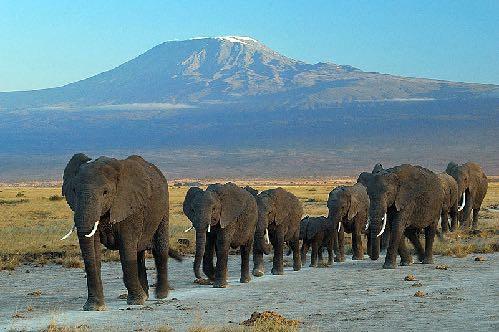
Mount Kilimanjaro is not only Africa’s tallest peak, but also the world’s tallest free standing mountain. The summit, named Uhuru Point, is 5,895 meters (19,341 feet) above sea level. Free standing mountains like Kilimanjaro are usually a result of volcanic activity. Volcanic mountains are formed when molten rock erupts, and piles upon the surface. Mount Kilimanjaro lies just 205 miles from the equator, in the country of Tanzania. When early explorers reported seeing glaciers on the top of Kilimanjaro, people did not believe them as they thought it was impossible for ice to form so close to the hot, equatorial sun.
Itinerary Prices
riders sharing accommodation basis – USD 3,990 per person
riders in single accommodation basis – USD 4,250 per person
pillion rider sharing accommodation basis – USD 2,250 per person
Tarangire National Park USD 180 per person
LOCATION FACTS
Mount Kilimanjaro is not only Africa’s tallest peak, but also the world’s tallest free standing mountain. The summit, named Uhuru Point, is 5,895 meters (19,341 feet) above sea level. Free standing mountains like Kilimanjaro are usually a result of volcanic activity. Volcanic mountains are formed when molten rock erupts, and piles upon the surface. Mount Kilimanjaro lies just 205 miles from the equator, in the country of Tanzania. When early explorers reported seeing glaciers on the top of Kilimanjaro, people did not believe them as they thought it was impossible for ice to form so close to the hot, equatorial sun.
Mount Kilimanjaro is a stratovolcano – a term for a very large volcano made of ash, lava, and rock. Shira and Mawenzi Peaks are extinct volcanoes, meaning that there is no activity underneath these cones. In short, they are cut off from their supply of lava.
However, Kibo Peak is considered a dormant volcano; it can erupt again! If a volcano hasn’t erupted in the last 10,000 years, but scientists think it will erupt again, it’s considered dormant. The last major eruption was 360,000 years ago. The most recent activity was 200,000 years ago. The ash pit is a two hour round trip hike from the highest campsite, Crater Camp. Those who visit the ash pit will be greeted by the smell of sulphur from the volcano’s lava.
The origin of the name Kilimanjaro is not certain. European explorers had adopted the name by 1860 and reported that “Kilimanjaro” was the mountain’s Swahili name. But according to the 1907 edition of The Nuttall Encyclopædia, the name of the mountain was “Kilima-Njaro,” comprised of the Swahili word “Kilima” meaning “mountain” and the Chagga word “Njaro” meaning “whiteness.” German missionary Johann Ludwig Krapf wrote in his Missionary Labours (1860), “The Swahili the coast call the snow-mountain Kilimanjaro, “mountain of greatness,” may also mean “mountain of caravans” (kilima – mountain; jaro caravans), a landmark for caravans seen everywhere from afar, but the inhabitants of Jagga call it Kibo, ‘snow.’ Another possibility is that Kilimanjaro is the European pronunciation of a KiChagga phrase meaning “we failed to climb it.”
Lake Natron is situated in northern Tanzania on the border with Kenya, close to the Serengeti National Park and the Ngorongoro Conservation Area. The lake is in the vicinity of the active volcano, Ol Doinyo Lengai, which lies on the southern part of the lake. Lake Natron covers an area 56 km (35 miles) long and 24 km (15 miles) wide but the water level changes due to evaporation. The shallow and alkaline lake has different springs, the Ewaso Ng’iro River and different hot springs. The surface of Lake Natron, which has high salt, magnesite and sodium carbonate concentration, is covered with a pinkish-white soda crust.
The area around the lake offers different attractions such as a large number of volcanic implosion craters, numerous waterfalls, and ravines with nesting places for Rüppell’s Griffon Vultures. Among the most prominent attractions of Lake Natron is the Gelai Volcano, a 2,942 m (9,652 feet) high volcano on the southeastern part of the lake, and the archeological site of ‘Peninj’, where archeologists discovered the ‘Peninj Mandible’ – the fossilised teeth of Australopithecus boisei. Some of the activities at Lake Natron are swimming in pools around the waterfalls and hot springs, a visit to Maasai villages, hiking to the top of the active volcano of Ol Doinyo Lengai, and trekking to the Ngorongoro Crater Highlands consists of numerous volcanic craters.
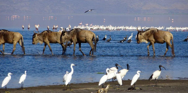
The area has beautiful wildlife, and it serves as a breeding place for thousands of Lesser Flamingos. They construct their nests between August and October using the soda flats. The Flamingos of Lake Natron feed on the lake’s Spirulina algae. Because the Flamingos use this area for breeding, the lake and its surroundings are under international concern for preservation. Other animals which inhabit this area are the Zebra, Giraffe, Wildebeest, Ostrich, Fringed Eared Oryx, Gazelle, Gerenuk, Lesser Kudu, and Golden Jackal. Lake Natron is an excellent area for one-on-one encounters with wildlife while riding a motorcycle.
The area has beautiful wildlife, and it serves as a breeding place for thousands of Lesser Flamingos. They construct their nests between August and October using the soda flats. The Flamingos of Lake Natron feed on the lake’s Spirulina algae. Because the Flamingos use this area for breeding, the lake and its surroundings are under international concern for preservation. Other animals which inhabit this area are the Zebra, Giraffe, Wildebeest, Ostrich, Fringed Eared Oryx, Gazelle, Gerenuk, Lesser Kudu, and Golden Jackal. Lake Natron is an excellent area for one-on-one encounters with wildlife while riding a motorcycle.
Lake Eyasi is a seasonal shallow endorheic salt lake on the floor of the Great Rift Valley at the base of the Serengeti Plateau, just south of the Serengeti National Park and immediately southwest of the Ngorongoro Crater in the Crater Highlands of Tanzania. The lake is elongated, oriented southwest to northeast, and lies in the Eyasi-Wembere branch of the Great Rift Valley. The Hadzabe bushmen live in this region, as do the Datoga and Mbulu tribes. A visit with the bushmen is worthwhile, and they will graciously show you where and how they live and hunt. They subsist entirely off the bush and by bow hunting. Everything they use is made from local materials, including their bows, which are strung with giraffe tendon and their arrows, which are coated in lethal poison. Their language resembles that of the Kalahari bushmen tribe (who were featured in the 1980 film ‘The Gods Must Be Crazy’), with clicking noises used. The Datoga and Mbulu people are pastoralists, like the Masai people. The scenery of Lake Eyasi differs dramatically from that of the surrounding areas. Compared to the Serengeti and Ngorongoro Highlands, this area seems downright tropical. Palm trees border the lake and make homes for birds such as Fischer’s Lovebird. Other trees in this area include the Umbrella Thorn Acacia and Sand Paper Bush. The weather is nearly always very hot and intense, as the lake is located on the floor of the Rift Valley, the oldest rift in the world.
Lake Eyasi is a seasonal shallow endorheic salt lake on the floor of the Great Rift Valley at the base of the Serengeti Plateau, just south of the Serengeti National Park and immediately southwest of the Ngorongoro Crater in the Crater Highlands of Tanzania. The lake is elongated, oriented southwest to northeast, and lies in the Eyasi-Wembere branch of the Great Rift Valley. The Hadzabe bushmen live in this region, as do the Datoga and Mbulu tribes. A visit with the bushmen is worthwhile, and they will graciously show you where and how they live and hunt. They subsist entirely off the bush and by bow hunting. Everything they use is made from local materials, including their bows, which are strung with giraffe tendon and their arrows, which are coated in lethal poison. Their language resembles that of the Kalahari bushmen tribe (who were featured in the 1980 film ‘The Gods Must Be Crazy’), with clicking noises used. The Datoga and Mbulu people are pastoralists, like the Masai people. The scenery of Lake Eyasi differs dramatically from that of the surrounding areas. Compared to the Serengeti and Ngorongoro Highlands, this area seems downright tropical. Palm trees border the lake and make homes for birds such as Fischer’s Lovebird. Other trees in this area include the Umbrella Thorn Acacia and Sand Paper Bush. The weather is nearly always very hot and intense, as the lake is located on the floor of the Rift Valley, the oldest rift in the world.
Lake Eyasi is a seasonal shallow endorheic salt lake on the floor of the Great Rift Valley at the base of the Serengeti Plateau, just south of the Serengeti National Park and immediately southwest of the Ngorongoro Crater in the Crater Highlands of Tanzania. The lake is elongated, oriented southwest to northeast, and lies in the Eyasi-Wembere branch of the Great Rift Valley. The Hadzabe bushmen live in this region, as do the Datoga and Mbulu tribes. A visit with the bushmen is worthwhile, and they will graciously show you where and how they live and hunt. They subsist entirely off the bush and by bow hunting. Everything they use is made from local materials, including their bows, which are strung with giraffe tendon and their arrows, which are coated in lethal poison. Their language resembles that of the Kalahari bushmen tribe (who were featured in the 1980 film ‘The Gods Must Be Crazy’), with clicking noises used. The Datoga and Mbulu people are pastoralists, like the Masai people. The scenery of Lake Eyasi differs dramatically from that of the surrounding areas. Compared to the Serengeti and Ngorongoro Highlands, this area seems downright tropical. Palm trees border the lake and make homes for birds such as Fischer’s Lovebird. Other trees in this area include the Umbrella Thorn Acacia and Sand Paper Bush. The weather is nearly always very hot and intense, as the lake is located on the floor of the Rift Valley, the oldest rift in the world.
The rift is thought to have opened over 65 million years ago, shortly after dinosaurs became extinct. Lake Eyasi’s water levels vary greatly between the rainy and dry seasons. During the dry season, the lake is virtually nonexistent and animals are forced to share what water is left, which makes for easier wildlife viewing. The lake can get quite deep during the rainy season, and it attracts hippos who like to cool off in its brackish waters.
Bird lovers will be in paradise here, as the lake attracts vast numbers of birds of all sizes and colors. Some main birds to be found here include: African Spoonbill, Flamingos, Grey-Headed Gulls, Great White Pelicans, Pied Avocet and Yellow-Billed Storks. The main fish found in the lake are Catfish and Lungfish. This region is particularly suited for exploring on foot, and a day or half-day hikes are highly recommended. It is also possible to go on a hunting trip with the Hadzabe or to visit the other tribes. Almost any time of year is a good time to visit Lake Eyasi with only April and May being questionable as they are when the long rains occur.
Lake Manyara is the seventh-largest lake of Tanzania by surface area, at 470-square-kilometres (180 sq mi). It is a shallow, alkaline lake in the Natron-Manyara-Balangida branch of the East African Rift in Manyara Region in Tanzania. The northwest quadrant of the lake (about 200 sq. km.) is included within Lake Manyara National Park and it is part of the Lake Manyara Biosphere Reserve, established in 1981 by UNESCO as part of its Man and the Biosphere Programme.
There are differing explanations for how Lake Manyara got its name. The name Manyara may come from the Maasai word emanyara, which is the spiky, protective enclosure around a family homestead (boma). Possibly the 600 m high rift escarpment hems in the lake, like the enclosure around a Maasai boma. Another theory is that the Mbugwe tribe, who live in the Lake Manyara area, may have given the lake its name based on the Mbugwe word manyero, meaning a trough or place where animals drink water. Lake Manyara National Park is known for flocks of thousands flamingos that feed along the edge of the lake in the wet season. At times, there have been over an estimated 2 million individuals of various species of water birds. Lake Manyara can be accessed through Lake Manyara National Park. With an entrance gate that doubles as an exit, the trail into the park is effectively a loop that can be traversed by jeep within a few hours. The trails goes through forests shrublands and marsh, before reaching the shore of the lake. The Rift Valley escarpment provides a spectacular backdrop. From the nearby town of Mto wa Mbu, through the Cultural Tourism Programme, it is possible to organize a canoe trip on the lake, or a fishing trip to learn traditional fishing methods. Bicycle trips to the east shore of the lake can also be arraigned.
The Ngorongoro Crater Conservation Area is a protected area and a World Heritage Site located 180 km (110 mi) west of Arusha in the Crater Highlands area of Tanzania. The area is named after Ngorongoro Crater, a large volcanic caldera within the area. The conservation area is administered by the Ngorongoro Conservation Area Authority, an arm of the Tanzanian government, and its boundaries follow the boundary of the Ngorongoro Division of the Arusha Region.
The 2009 Ngorongoro Wildlife Conservation Act placed new restrictions on human settlement and subsistence farming in the Crater, displacing Maasai pastoralists, most of whom had been relocated to Ngorongoro from their ancestral lands to the north when the British colonial government established Serengeti National Park in 1959. The main feature of the Ngorongoro Conservation Authority is the Ngorongoro Crater, the world’s largest inactive, intact, and unfilled volcanic caldera. The crater, which formed when a large volcano exploded and collapsed on itself two to three million years ago, is 610 metres (2,000 feet) deep and its floor covers 260 square kilometres (100 square miles). Estimates of the height of the original volcano range from 4,500 to 5,800 metres (14,800 to 19,000 feet) high. The crater floor is 1,800 metres (5,900 feet) above sea level. The crater was voted by Seven Natural Wonders as one of the Seven Natural Wonders of Africa in Arusha, Tanzania, in February 2013.
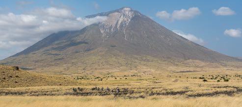
The Ngorongoro volcano was active from about 2.45 to 2 million years ago. The volcanic eruptions like that of Ngorongoro, which resulted in the formation of Ngorongoro Crater in Tanzania, were very common. Similar collapses occurred in the case of Olmoti and Empakaai, but they were much smaller in magnitude and impact. Out of the two recent volcanoes to the northeast of the Empakaai caldera, Kerimasi and Ol Doinyo Lengai, Doinyo Lengai is still active and had major eruptions in 2007 and 2008. Smaller ash eruptions and lava flows continue to slowly fill the current crater. Its name is Maasai for ‘Mountain of God’.
The Munge Stream drains Olmoti Crater to the north, and is the main water source draining into the seasonal salt lake in the center of the crater. This lake is known by two names: Makat as the Maasai called it, meaning salt; and Magadi. water supplies for the animals and local Maasai, as you were previously permitted to graze their cattle within the crater, but as of 2015 were restricted from doing so. The other major water source in the crater is the Ngoitokitok Spring, near the eastern crater wall. There is a picnic site here open to tourists and a huge swamp fed by the spring, and the area is inhabited by hippopotamuses, elephants, lions and many others. Many other small springs can be found around the crater’s floor, and these are important water supplies for the animals and local Maasai, especially during times of drought. Masai were previously permitted to graze their cattle within the crater, but as of 2015 were restricted from doing so.